 |
HOME - ENGLAND - EAST RIDING
Dedication: Saint George Location: Fishergate Status: lost |
Although it is not known when exactly Fishergate's church of St George was constructed, the earliest known documentary reference to it dates from 1291, and, as St George's Well undoubtedly took its name from its dedication, it is probable that the holy well would have existed at this time. Until 1585, at least according to the first volume of Francis Drake's Eboracum (1788), St George's was a parish in its own right, and all of the area's baptisms would almost certainly have been carried out at this spring. Whether the holy well was still used for its original purpose after this date is unclear, but it is very likely to have fallen out of regular use, at least in terms of performing baptisms, after the 1644 Siege of York, when St George's Church suffered damage that was never repaired; by the 19th century, nothing remained of the building apart from the churchyard.
Even if St George's Well ceased to be frequently used for religious purposes, its location makes it likely that the spring would have continued to be used for practical reasons. In fact, Thomas Gent, who is really the only authority that I have found regarding the history of St George's Well, wrote in 1733, in The Antient and Modern History of the Loyal Town of Rippon [sic], that "St. George's Well" then possessed "a decent Chain and Baſon [sic]" that had been installed by a "Gentleman" named "Jonas Thompson", who was Lord Mayor of York between the years of 1731 and 1732. Thompson appears to have taken a direct interest in the maintenance of a number of the city's water sources, and Gent recorded that he had also improved the appearance of the "Piking-Well", located elsewhere in the city.
Unfortunately, I have been unable to find a record of what St George's Well looked like before its structure was altered by Jonas Thompson, and the earliest reference that I have found to the site dates from 1730, when Thomas Gent briefly mentioned the "pleaſant Spring" in his Antient and Modern History of the Famous City of York; presumably this was before Thompson installed the basin and chain, assuming that he did so during his time as Lord Mayor. Either way, the improvements made to the site by him do show that St George's Well was in frequent use as a local water supply.
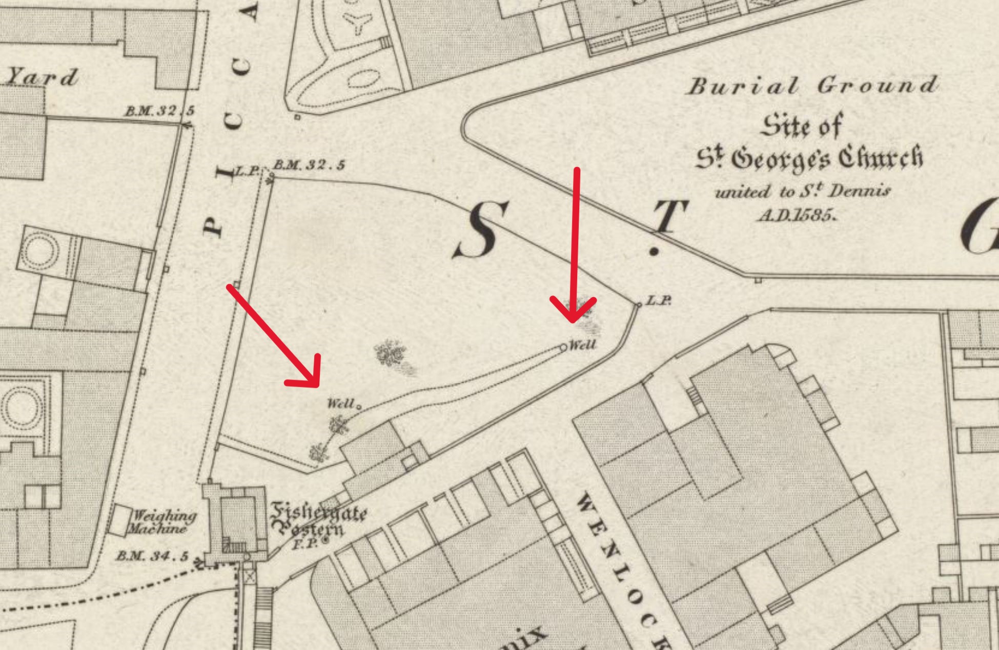
More unfortunate than the lack of historical records relating to the holy well is the fact that there is no definitive record of its location. The site has been, inexplicably, omitted from the Historic Environment Record, and no historic Ordnance Survey maps explicitly depict St George's Well; in this instance, only the notes of Thomas Gent can help to identify its location. In his aforementioned History of York (1730), Gent simply recorded that St George's Well was situated "near the Church-Yard" of "St. George within Fiſhergate-Bar", but it is in the History of Rippon [sic] (1733) that Gent is much more specific. In this volume, he described the spring as being "near Fiſher Gate Poſtern", "not far from" St George's Church, which suggests that the holy well must have been somewhere inbetween the postern, a medieval tower connected to the city walls, and the site of the church. This theory is supported by the OS town plan of 1852, which depicts two unnamed wells, in close proximity, at this approximate location. Most interestingly, the map does not mark any other water sources in the vicinity, which implies that, assuming St George's Well survived into the 19th century, it was one of these two springs, situated at SE6069151342 and SE6071251347.
Although they were in existence in 1852, by 1891, when the second edition of the OS town plan was issued, both water sources had been built over by the aptly named "St George's Saw Mills", and no pumps appear to have been installed at the roadside to maintain the supply. Today, the situation remains the same: despite the fact that St George's Saw Mills no longer exists on the site, a newer building still covers the area, and it is impossible to tell whether anything survives of the two springs.
|
The point on the above map is centred on the site of St George's Church
Images:
Old OS maps are reproduced with the permission of the National Library of Scotland
Copyright 2025 britishholywells.co.uk