 |
Dedication: Saint Crispin? Location: outside The Swan Coordinates: 51.31525N, 0.89185W* Grid reference: TR016613* Status: capped Heritage designation: none |
|
Dedication: Saint Crispin? Location: outside The Swan Coordinates: 51.31525N, 0.89185W* Grid reference: TR016613* Status: capped Heritage designation: none |
According to local tradition, St Crispin, along with his brother St Crispinian, travelled to Kent during the late 3rd century to escape persecution. The two saints are reputed to have been born into a Roman family of some social standing, at a time when Christianity was yet to be endorsed by the Roman Empire. The standard version of the legend asserts that, under threat of torture and execution, Crispin and Crispinian fled to Gaul, only to be executed at Soissons when their preaching attracted the attention of first the local Roman governor, Rictus Varus, and later the Roman Emperor himself. However, medieval Kentish variants of the saints' lives claim that Crispin and Crispinian escaped from Gaul to Faversham, where they resided with local leatherworkers and shoemakers for around six years, before returning to France and being executed at Soissons.
Whilst it is impossible to ascertain whether any part of their association with Faversham may be authentic, the tradition was obviously widespread throughout the area. Within the town itself, Crispin and his brother were once said to have inhabited a cottage on the present site of The Swan, and one of the parish church's many altars was, in medieval times, dedicated to the pair. Slightly further afield, there appears to have been some sort of medieval landmark, seemingly a stone cairn of some description that was believed to have been the "grave" of the two martyrs, located somewhere on the south-east coast, although it is difficult to locate exactly. (Whilst A Handbook for Travellers in Kent and Sussex, published by John Murray in 1858, refers to "heap of stones at the shore at Stone Point", near "Lydd", an anonymous letter included in The Antiquary in 1873 attests that it is situated at "Stone End, near Hythe"; perhaps there were actually two identical monuments.) Additionally, an inn has borne the dedication of St Crispin and St Crispinian since at least 1895, when it was mentioned by Charles G. Harper in The Old Dover Road.
Regarding the well itself, however, there is little evidence to prove that it was ever associated with the saints' cult, apart from its location. The earliest reference that I have found to the site dates from 1727, and appears in John Lewis' History and Antiquities of the Abbey and Church of Faverſham in Kent. According to Lewis, who claimed that Crispin and his brother had, at Faversham, "learnt to make ſhoos [sic] for a livelihood", the saints had lodged "at a Houſe in Preſton-ſtreet near the Croſſe-Well"; this house, he reported, was "now the ſign of the Swan". Although Lewis used the well as a reference point, he did not suggest that it had any links with the saints' cult.
Indeed, I have not found any sources, historical or otherwise (excluding the plaque attached to the south face of The Swan), that refer to the well as "St Crispin's", and the only source that I have found which establishes a potential link between the saint and the well is the aforementioned anonymous letter that was published in The Antiquary in 1873. This letter discussed "some odd legends about these Roman saints", particularly those associated with the town of Faversham, including that which is linked to The Swan. As a result of this, the author of the letter speculated that the "Crosse-well" nearby may have had some connection to this legend, but made it clear that this was no more than a conjecture:
|
Perhaps it was a holy well, and called SS. Crispin and Crispinian's; certainly they were somehow associated with the place, for an altar in the parish church was dedicated to them, and it is possible a legend was trumped up from this, and made to apply to the house close by. |
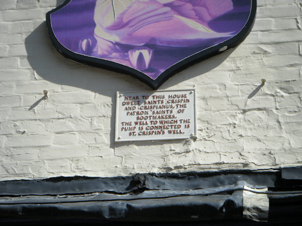
It appears that this statement was either misinterpreted, or the suggestion enthusiastically endorsed, by whoever had the aforementioned plaque erected at the site. Although I have not been able to pinpoint when exactly this plaque was commissioned, it must have been put up at some point after 1873; it seems to be this inscription which has, most probably inaccurately, given the Cross Well the title of "St Crispin's Well", which, therefore, has only been applied to the site for the last century or so. The contents of the plaque are as follows:
NEAR TO THIS HOUSE |
Interestingly, the name "Cross Well", which may initially appear to indicate that the well had some religious connections, actually refers to the fact that the spring was, historically, situated next to one of Faversham's four medieval crosses. Details of the locations of these crosses were published in 1774 in The History of the Town and Port of Faversham by Edward Jacob, who recorded that one had stood, "where the gallows was erected", a second "in Weſt-ſtreet", and another "at the entrance into Church-lane", whilst the fourth had been situated "at the bottom of Preſton-ſtreet, between Eaſt-ſtreet and Hogmarket-lane", where the Cross Well is located. Intriguingly, Jacob added that the "great ſtones" of the fourth cross had been "taken away" in 1574, and replaced by "a more uſeful column" through which "plenty of good water" issued. Clearly, Jacob was describing, albeit in rather flowery language, a pump; this pump, which, from Jacob's description, appears to have been located directly in the middle of the road, was fed by water from the Cross Well.
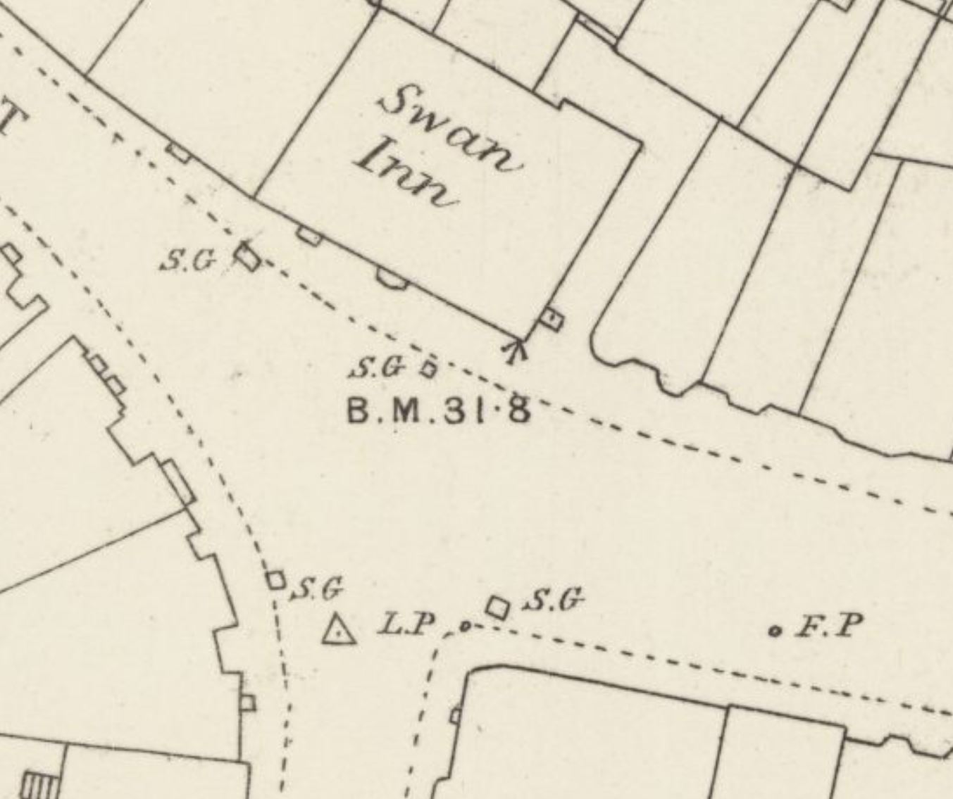
This pump, however, did not last forever. I have been unable to ascertain the exact date of its removal, but it had certainly been taken down by 1886, when the Ordnance Survey town plan of Faversham was published. This map makes it clear that, by the late 19th century, neither pump nor cross existed in the centre of the road; nevertheless, the town plan does depict an un-named structure at the entrance to Hogmarket Lane, on the west side, adjoining the east wall of The Swan, which appears to be a pump. The 1907 25-inch map of Faversham, which marks a large "P" at this location, confirms that this is the case. Presumably, then, the old pump of 1574 (or later, if the 16th century pump had already been replaced) was taken down and replaced with a newer pump at the entrance to Hogmarket Lane, only a few metres from the original site of the well, at some point before the 1886. Interestingly, this places the date of the plaque's erection, assuming that it remains in situ and has not been moved from a different position, between the years of 1873 (when the idea that the well was dedicated to St Crispin was first postulated) and 1886 (by which time the pump had moved from in front of The Swan, to beside it), as the plaque appears to refer to a pump situated directly in front of the pub.
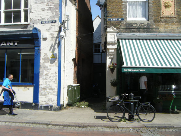
Just like its predecessor, this new pump was eventually removed, although the date of its removal appears to have been very recent, as I discovered when I visited Faversham for myself in August 2025. Inquiring about "St Crispin's Well" at the town hall, I was surprised to find that, locally, the name was well-known, as well as its location. Although I was initially informed that the well "is behind the butcher's", the butcher himself did not know anything about the site, had never heard of it before, and confirmed that there was nothing at all "behind" the building; there was, nevertheless, an alleyway (Hogmarket Lane) at the side. Returning to the town hall, a helpful volunteer offered to take me to the well itself: however, arriving at Hogmarket Lane, he was shocked to find that "the pump" had vanished. A passing local, who also knew of "St Crispin's Well", stopped to help, and, after confidently asserting that there was a pump somewhere in the alley, was also amazed to find that it had disappeared.
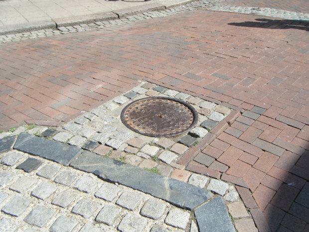
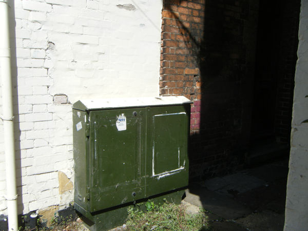
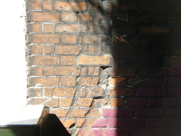
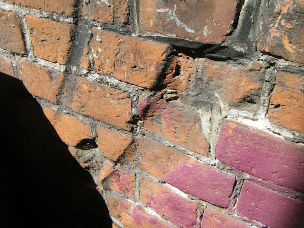
I was directed to Faversham museum, where a local history expert confirmed that the pump had once been located at the entrance to Hogmarket Lane, but had been taken down, and replaced by a green box of some description. He informed me that, according to local tradition, the large manhole cover, in the centre of the road in front of The Swan, marks the site of an older pump that was replaced by the one in Hogmarket Lane; this tradition has been proven to be true through my research. It is very likely that the original spring survives beneath this manhole cover. Additionally, he attested that the location of the newer pump in Hogmarket Lane could be identified by a set of semi-circular gouges, carved into the east wall of The Swan, that had been caused by the pump's handle. Upon re-visiting the alleyway, I saw these marks for myself.
 |
 |
 |
 |
 |
 |
|
Access: Both the site of the second pump and the manhole cover, beneath which the spring almost certainly still survives, are located in public areas and are easy to access |
*This is the location of the manhole cover (as photographed), which was the original location of the spring; the second pump, in Hogmarket Lane, was situated at exactly TR0162461325
Images:
Old OS maps are reproduced with the permission of the National Library of Scotland
Copyright 2025 britishholywells.co.uk