 |
Dedication: none Location: Mickley Coordinates: 54.95031N, -1.88177W Grid reference: NZ076617 Status: unknown |
HOME - ENGLAND - NORTHUMBERLAND
|
Dedication: none Location: Mickley Coordinates: 54.95031N, -1.88177W Grid reference: NZ076617 Status: unknown |
I have only found one reference, historical or otherwise, to the existence of a holy well within the parish of Mickley. This reference appears in A Memoir of Thomas Bewick, the contents of which, though published in 1862, after Bewick's death, were written by the man himself. He only mentioned the site once, whilst recounting the events of his early childhood, which he spent in the parish:
|
One of these old men, John Newton (the laird of the Neuk), almost every morning, while I was young, met me and my schoolfellows at or near the Haly Well (Holy Well) as we were going to Mickley School, and he seldom passed me without clapping my head, accompanied with some good wishes. |
Bewick was born, according to his Memoir, in "August, 1753", at Cherryburn, a house located on the edge of Mickley. He claimed in his Memoir that one of his earliest memories was "being sent to Mickley School when very young", which was done, according to him, not "with a view to my learning", but mostly to keep him out of trouble. Bewick did not stay long at this school, however, because he was later transferred to the village school at nearby Ovingham, where he was taught by the Rev. Christopher Gregson, Vicar of Ovingham. At the age of fourteen, he left school to become an engraver's apprentice, and went on to make a name for himself as a talented engraver.
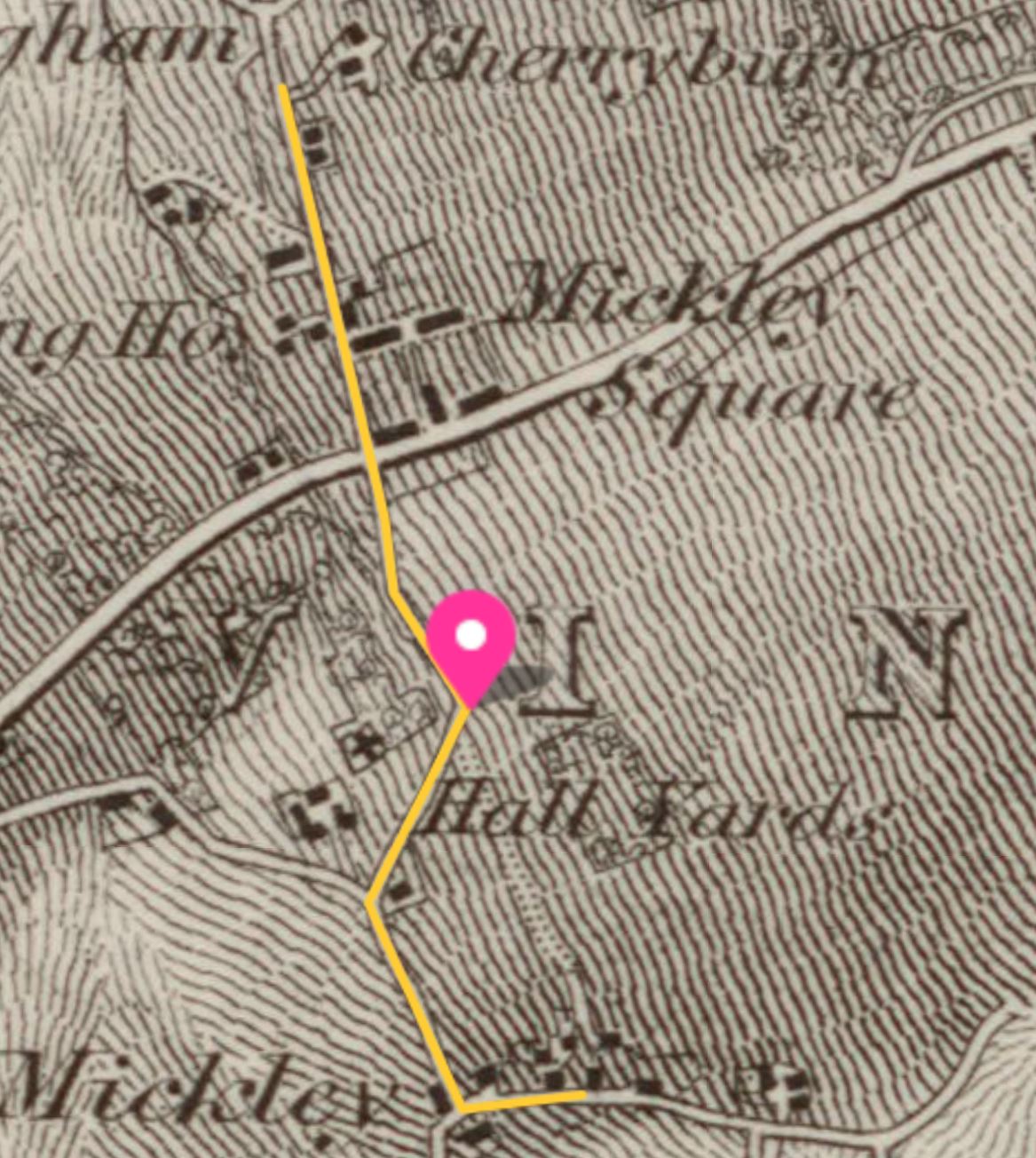
Clearly, the Holy Well was located partway between Cherryburn and Mickley School, directly on the route that Bewick would have taken as a schoolboy during the 1750s. Unfortunately, by the time that the first Ordnance Survey maps of the area were produced, roughly a century later, multiple schools had been set up within the parish. On the 1865 6-inch OS map of Mickley, two different establishments are marked: a "National School" situated near to Cherryburn, and a second school, described simply as "School (Boys & Girls)", located within the village itself. Nevertheless, it is clear which school Bewick would have attended, as so-called "National Schools" were set up during the 19th century to improve education for the poor, meaning that Mickley's "National School" cannot have been the one that Bewick was referring to. Instead, this suggests that he must have been a pupil at the school located within Mickley itself, which is confirmed by David Croal Thomson's statement (included in 1882 in The Life and Works of Thomas Bewick) that Ovingham School was "about a mile from Cherryburn", just, according to Thomson, "like Mickley" School. As the other school marked on Ordnance Survey maps is located almost exactly a mile from Cherryburn, there can be no doubt that this was the institution to which Bewick referred.
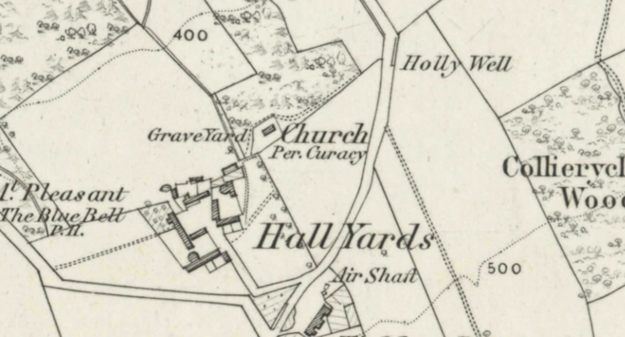
Historic Ordnance Survey maps depict a network of small lanes and roads in the vicinity, most of which would have also been roads or tracks during Bewick's childhood, and it is possible to trace the route that he would have taken to Mickley School every morning. He almost certainly would have taken the road that leads south from Cherryburn to Mickley, along Eastgate Bank, and then turned east along the main street in the village, until he reached Mickley School. Presumably, then, the Holy Well must have been situated somewhere along this route, most probably beside the road. It is, therefore, surely no coincidence that the 1865 6-inch Ordnance Survey map marks a "Holly Well" approximately half-way between the two places, at the side of Eastgate Bank, opposite St George's Church. Unusually, the majority of the water sources in the area are named on this edition, and this is the only one that has a name that in any way resembles that of the spring to which Bewick referred.
 |
It seems quite likely that, by the 1860s, the name "Holy Well", or "Haly Well", as Bewick described it, had become corrupted into "Holywell", pronounced "Holly Well", which would explain why OS surveyors mistakenly labelled it as they did. Indeed, there is strong evidence that "Holywell" had become, by the late 19th century, the standard way of spelling the site's name: at some point after 1865, as later OS maps show, a group of houses were constructed nearby, at around NZ0707861750, called "Holywell Terrace".
Despite the fact that the name was then known locally, the "Holly Well" vanished from OS maps completely after 1865. Whether the well still existed, but was simply not depicted on maps, is not clear, although the construction of Holywell Terrace suggests that this was the case. Of course, as modern Ordnance Survey maps do not mark a spring at this site either, it is impossible to tell whether the Holy Well still exists.
It is worth noting that the well's proximity to St George's Church, which may appear to suggest a link between the two sites, is actually insignificant, as St George's Church was constructed from scratch in the early 19th century as a chapel of ease.
|
Access: The Holy Well, or the site of it, is located at the side of a quiet public road. |
Images:
Old OS maps are reproduced with the permission of the National Library of Scotland
Copyright 2025 britishholywells.co.uk