 |
 |
 |
 |
 |
 |
HOME - ENGLAND - NORTHUMBERLAND
Dedication: Saint Kentigern Location: Tweedmouth Status: lost |
St Kentigern, more commonly known by his nickname "Mungo", was a late 6th century missionary and bishop. Although he was, according to tradition, born in Fife, and seems to have spent the majority of his time in that approximate area, he clearly did not confine himself to Scotland. As well as founding both Glasgow Cathedral and, on a journey to Wales, the Cathedral of St Asaph, Kentigern is credited with the foundations of a large number of churches across the north of England, including St Michael's Church at Arthuret in Cumberland. Although most of these churches are located in the north-west of the country, the existence of a number of churches dedicated to the saint in Northumberland, in addition to the fact that Tweedmouth possessed one of his many holy wells, suggests that Kentigern's medieval cult, if not the man himself, once had a presence in the area.
Despite the fact that the site must have been well-known, if only locally, during medieval times, I have only found one reference, historical or otherwise, to the existence of this well. This reference dates from 1853, and can be found in The Botany of the Eastern Borders, by George Johnston, who mentioned a well "in Tweedmouth" that he claimed was dedicated "to Saint Mugnus", the name of which had become "strangely corrupted" into "Meggie-Muggie's well". Johnston did not elaborate on the subject, which is particularly unfortunate given that he is the only authority regarding it, thus leaving the rest of the well's history to speculation.
Although Johnston did not confirm the identity of the saint to which he referred, it is very clear that by "Mugnus" he meant "St Mungo". "Mugnus" or "Magnus" appear to have been common renderings of "Mungo", St Mungo's Well at Knaresborough in North Yorkshire, which was once variously known as "St Mugnus' Well" or "St Magnus' Well", bearing testament to this particular phenomenon. Presumably, the corruption of "Mugnus" into "Meggie-Muggie" occurred after the spring ceased to be used for religious purposes, at some point after the Reformation, and this is not the only known instance of such an occurrence: St Mungo's Well at Simonburn, also in Northumberland, was often referred to as "Mugger's Well" following the Reformation.
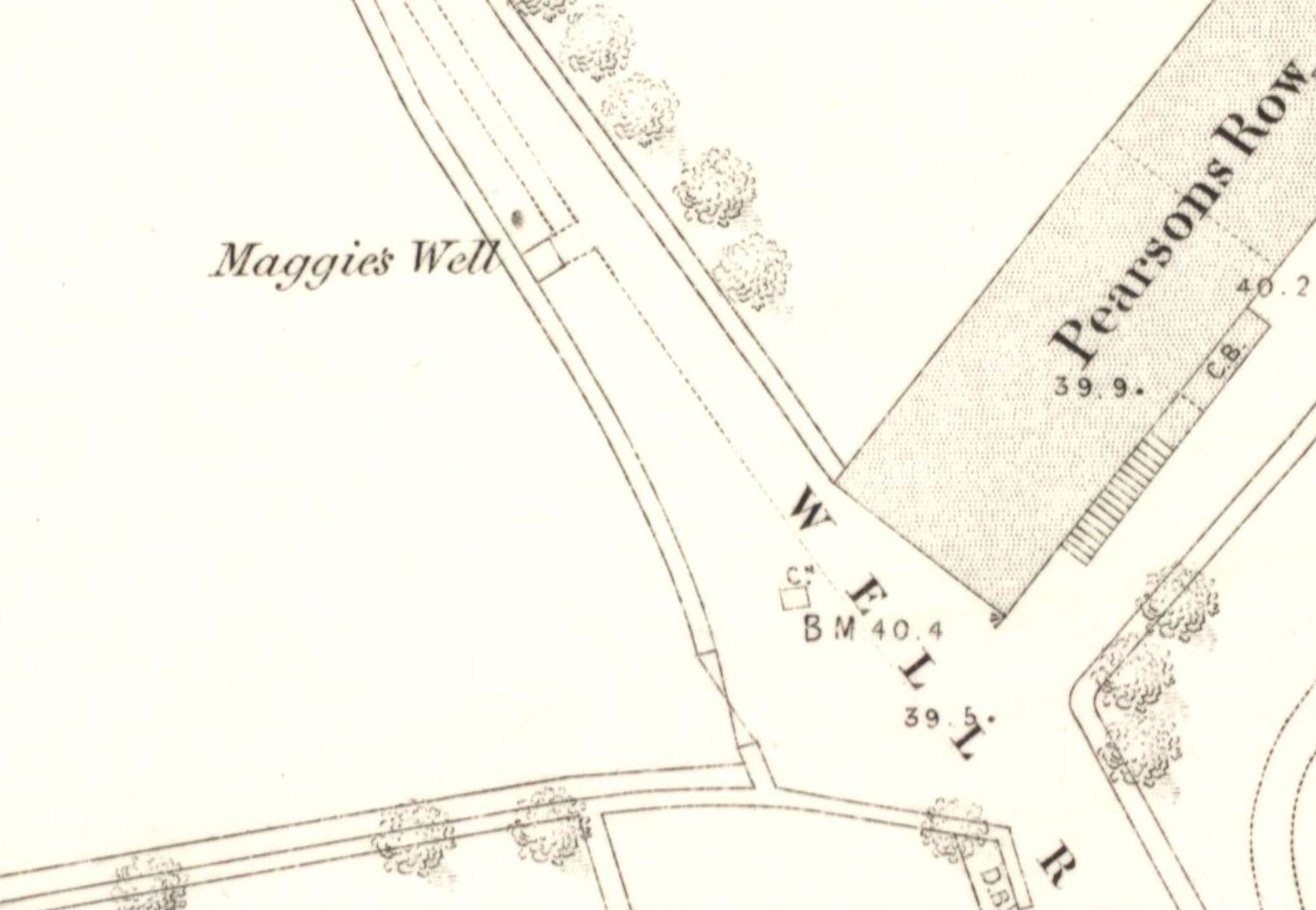
There is, unfortunately, no record of the exact location of Meggie-Muggie's Well, as no site with that name appears on any historic Ordnance Survey maps of the area, and it is not included on the Historic Environment Record. Nevertheless, the only clue that Johnston provided as to the situation of the spring (that it is, or was, located "in Tweedmouth") does considerably narrow down the search. In 1853, Tweedmouth was a relatively small place, and although Ordnance Survey maps have never shown a well in the town with the name described by Johnston, historic editions did once name a "Maggie's Well" near the church, at NT9957452166, that is very likely to have been the holy well.
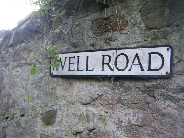
This spring was first marked on the OS town plan of Tweedmouth, published in 1855, only two years after Johnston's book was published, as "Maggie's Well". According to both this and later maps, Maggie's Well was located at the side of a small lane called "Well Road", the north end of which adjoined "Well Square"; as there are no other wells or water sources marked on OS maps in the vicinity, these places must take their names from the existence of this spring, suggesting that it was once of local importance. The site continued to be marked and named on Ordnance Survey maps until 1938, after which time the location of Maggie's Well was only denoted by a "W". It had evidently fallen out of regular use by the 1960s, and was presumably filled in around that time, as it ceased to be marked on Ordnance Survey maps from then onwards. I have been unable to find any information regarding Maggie's Well, including the origin of its name, apart from the fact that it was marked on historic OS maps.
There is a considerable amount of evidence to suggest that Maggie's Well was indeed the same as "Meggie-Muggie's". Firstly, the similarity of the names is such that it cannot be ignored: there are no named wells in or around Tweedmouth that have a title that in any way resembles "Meggie-Muggie", apart, of course, from Maggie's Well. As the original name of the site (which presumably would have been something like "St Mugnus' Well") had already become corrupted into "Meggie-Muggie", it is not difficult to imagine that it later became further corrupted into "Maggie". Additionally, Maggie's Well is located very close to the church, in the centre of Tweedmouth, which would indicate that it was originally a central point in the town, as does the fact that it gave its name to the surrounding streets.
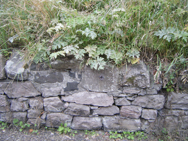
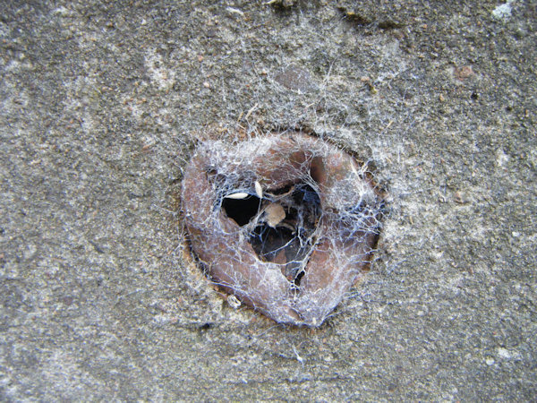
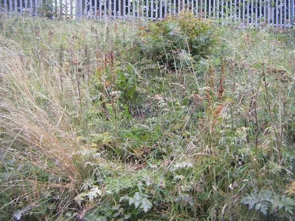
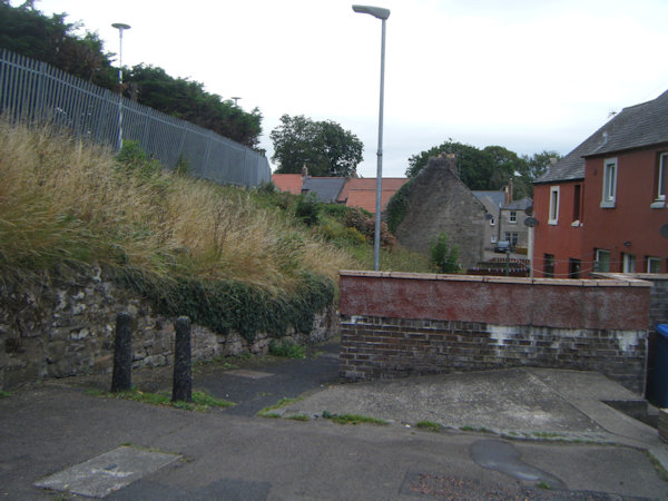
When I visited the site of Maggie's Well in July 2025, I was not surprised, given the fact that it had disappeared from Ordnance Survey maps some six decades previously, to find that there was no longer a spring at the relevant location. Nonetheless, something of Maggie's Well still remained: in the side of the wall that ran along the western edge of Well Road (now a small alleyway), I noticed an infilled metal pipe, protruding from a large stone, on the exact site of Maggie's Well. Although it was impossible to tell if any structural remains survived in the grassy bank above the wall, some traces of a structure may remain beneath the weeds.
|
|
|
|
|
|
Images:
Old OS maps are reproduced with the permission of the National Library of Scotland
Copyright 2025 britishholywells.co.uk