 |
Dedication: Saint Anne Location: Arlescote Woods Coordinates: 52.131418N, -1.427841W Grid reference: SP392482 Heritage designation: none |
HOME - ENGLAND - WARWICKSHIRE
|
Dedication: Saint Anne Location: Arlescote Woods Coordinates: 52.131418N, -1.427841W Grid reference: SP392482 Heritage designation: none |
Little is known about the history of Arlescote's holy well, and, for that reason, its legitimacy as a holy well has been called into question. Up until very recently, it was simply marked on OS maps as an unnamed "spring", and, on today's OS maps, althouh it is named, it is not marked in Gothic script (as historical landmarks are), which indicates that there is little evidence for its antiquity. With this, the possibility arises that the well was built as a sort of folly by the landowner in the early 20th century.
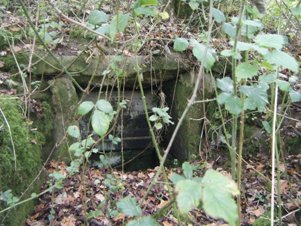
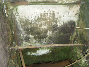
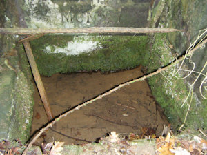
However, carved into the back of the stone structure in which the well's water arises is the words "St Anne's Well / Reparavit [here two unidentifiable letters; possibly "J L"] / A.D. MCMXI". "Reparavit" is the Latin word for "repaired"; it is possible that the following two letters are the initials of the person who repaired the structure, or it could be the remains of another word. "A. D. MCMXI" is the year 1912. From this, it is clear that the well was repaired in 1912. Interestingly, this corresponds with the 1955 OS map for Arlescote, which marks St Anne's Well in Gothic script (it was evidently thought to be old back then), and says beneath it "restored". It is therefore almost certain that, although the current structure is not of much age, the dedication to St Anne is itself much older.
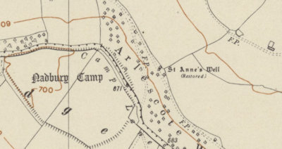 |
Strangely, the 1973 OS map, as well as all OS maps that succeeded it, does not mark the well in Gothic script, although the well is named. What made the surveyors suddenly doubt its age? It is, admittedly, odd that all of the OS maps from between the years of 1912 and 1955 only mark the well as a spring, when it was evidently by that time something much more substantial. It seems likely that the surveyors between those years did not revisit the spot, or did not find it (it is in a very overgrown place), and simply went on data that had been collected for the earlier OS maps. Before it was restored in 1912, it was probably little more than a spring.
Whilst no traditions are recorded about the well (almost nothing is), there is a definite possibility that its water was used for centuries, as there was once an Iron Age hillfort, known as Nadbury Camp, at the top of the hill that St Anne's Well is located at the bottom of. The site of the hillfort is only a few hundred metres to the west of the well; was it used by the Iron Age inhabitants of the hillfort as a supply of water, or was it even worshipped by them, as so many springs were? Did St Anne's Well start off as a Pagan sacred spring?
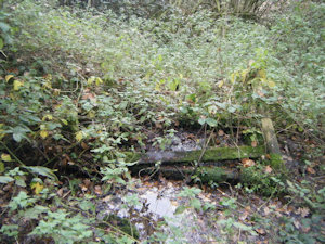
Today, the well can be found beside a public footpath, on the edge of Arlescote Wood. The stone structure is built into the dirt bank of the hillside, and flows out of the well into the remains of a stone trough of some kind, and from thence into a field.
 |
 |
 |
 |
|
Access: The well is located at the side of a public footpath. |
Images:
Old OS maps are reproduced with the permission of the National Library of Scotland
Copyright 2025 britishholywells.co.uk