 |
Dedication: Saint Edith of Polesworth Location: The Hermitage Coordinates: 52.61791N, -1.62969W* Grid reference: SK251023* Status: destroyed |
HOME - ENGLAND - WARWICKSHIRE
|
Dedication: Saint Edith of Polesworth Location: The Hermitage Coordinates: 52.61791N, -1.62969W* Grid reference: SK251023* Status: destroyed |
Apart from the fact that she certainly existed at some point before the 11th century, and was a member of the nunnery at Polesworth, nothing is known for certain about St Edith of Polesworth's life. Sabine Baring-Gould, in The Lives of the Saints (1898), identifies three separate variants of Edith's story, each of which places her in a different century. According to Matthew of Paris, a 13th century chronicler and monk, Edith, or as he described her, "Eadgitha", was a sister of King Athelstan, thus placing her in the 10th century; she is said by him to have become a nun at Polesworth after her pagan husband, Sithric, died. Another strain of the story makes Edith the sister of Alfred the Great, placing her in the 9th century; Sabine Baring-Gould claimed that this version is entirely made up. A third variant of the legend asserts that Edith founded the nunnery herself and was its first abbess. In fact, it is more likely that none of these stories are entirely true, and that the historical Edith was a mixture of these different characters.
Clearly even medieval pilgrims to Polesworth would not have had a very clear idea of who St Edith really was. This evidently did not matter to them, however, as the nunnery became known as the burial place of the saint, and pilgrims certainly travelled there prior to the Reformation. Interestingly, St Edith's Well was located beside one of the main routes into Polesworth, and it is likely that pilgrims would have stopped off at the well before visiting Polesworth nunnery itself.
Although the earliest reference that I have found to the existence of the well dates from 1730, the site had definitely already been of significance for several centuries. At some point (according to William Dugdale), probably during the late medieval period, William Savage, the Lord of Pooley, gifted a portion of land called "Povele Wood" to Polesworth nunnery. Contained within this wood was St Edith's Well, or at least the spring that became it; it is not clear whether the nuns created the well themselves to attract more pilgrims, or whether it had already appeared as a result of the dominance of Edith's cult in the immediate area. Either way, a chapel had been constructed directly over the spring by the time of the Reformation. It is, again, not evident whether it was the nuns or William Savage who built this chapel, but its existence undoubtedly benefitted the nuns either way.
This chapel miraculously survived the Reformation intact, and was still extant in 1730, when William Dugdale wrote his Antiquities of Warwickshire Illustrated. It appears that, by this time, the well had been mostly forgotten, and the chapel had been instead dubbed "the hermitage", with it becoming common belief that it had been inhabited by female hermits in medieval times. Perhaps it was this almost certainly errant assumption that saved the well-chapel, which appears to have been quite elaborate, from complete destruction. Dugdale's description of the site was published in the second edition of volume 2 of the Illustrated Antiquities:
|
This, being built of Stone, is ſtill extant, and near the Road way leading from Polesworth to Tamworth; under the end whereof is a fair Spring, running from a Rock; which Spring I take to be it whereof I have already made mention by the name of S. Edith's Well in boſco de Povele; for the grounds thereabouts were an Outwood, Pooley Park being not made till King Henry the ſeventh's time, as I ſhall ſhew anon. Thoſe that lived Heremitically at this place, were women, as it ſeems; for in the window of this little Cell, are the pictures of ſuch, in ſurcoats of Armes, as I have here expreſt. |
Dugdale included an illustration of this window, which presumably contained medieval stained glass that remained from the medieval chapel:
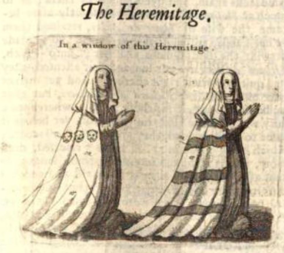 |
It is worth noting that the nuns' robes bear two different coats of arms. According to the Victoria County History account of Polesworth parish, one is "of the Herthill family", and the other depicts "a mantle of the arms of Swinfen"; perhaps these families were two benefactors of the chapel (this would suggest that it was constructed by the nunnery).
The fifth volume of the Survey of the Ancient and Preſent State of Great-Britain, published in 1738, included another reference to St Edith's Well and the so-called "Hermitage". According to this publication, the chapel still existed, but was "now put to other Uſes", the exact details of which are uncertain. Unfortunately, it seems that the chapel was destroyed at some point after this. The site was still mentioned in books such as The Natural History of England, by Benjamin Martin (1763), and the 1775 Complete Gazetteer of England and Wales, but as all of these publications just paraphrased Dugdale, the chapel may well have already been pulled down. In any case, the site certainly did not exist by 1882, when the fact that it had disappeared was mentioned in volume 5 of The Midland Naturalist. Whether St Edith's Well itself survived the chapel's destruction is unclear.
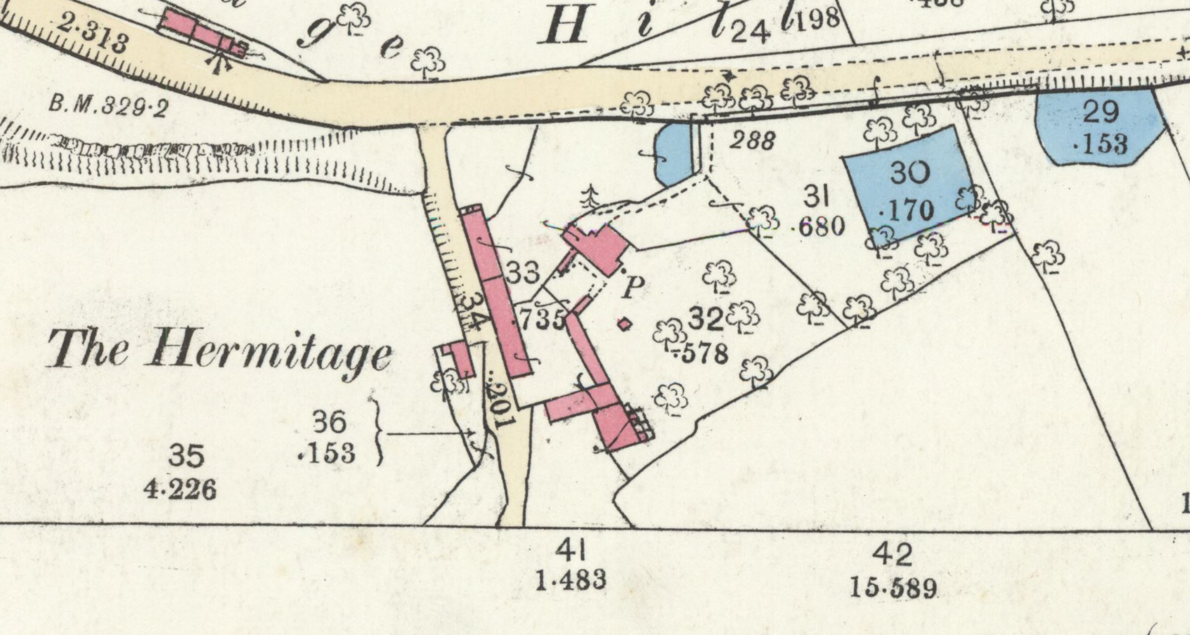
The exact location of the "Hermitage" is nowhere explicitly recorded. There are two places west of Polesworth, beside the road to Tamworth, that show the vague area in which the chapel and well were located, these being a farm called "Hermitage Farm", and, located slightly further north, a group of buildings termed "The Hermitage" on old Ordnance Survey maps. If it were not for the aforementioned article in The Midland Naturalist that referred to St Edith's Well, it would be impossible to tell which of these two are built on the exact site of the chapel and spring. According to The Midland Naturalist, "the hermitage with its series of fishponds" stood "on the site of St. Edith's Well"; this reference to the hermitage's fishponds prove that the well and chapel were located on the site of "The Hermitage", instead of "Hermitage Farm". Intriguingly, the 1884 25-inch OS map (as pictured above) of Polesworth marks a pump next to "The Hermitage", near to the fishponds - it is likely that this pump was a more modern incarnation of St Edith's Well.
This pump, assuming that it was the holy well, which is very likely, seems to have disappeared in the following decades, along with the fishponds, no traces of which exist today.
*This is the location of the pump, which was almost certainly St Edith's Well, as shown on Ordnance Survey maps
Images:
Old OS maps are reproduced with the permission of the National Library of Scotland
Copyright 2025 britishholywells.co.uk