 |
Dedication: Saint Erfyl Location: Llanerfyl Coordinates: 52.67704, -3.43164* Grid reference: SJ033097 Heritage designation: none |
HOME - WALES - MONTGOMERYSHIRE
|
Dedication: Saint Erfyl Location: Llanerfyl Coordinates: 52.67704, -3.43164* Grid reference: SJ033097 Heritage designation: none |
Very little is known about St Erfyl, a female virgin whose only patronage is Llanerfyl, its church, and her holy well, which would imply that Erfyl stayed in the area. She is rumoured to have been the daughter of St Padarn, and the cousin of St Cadfan, both of whom lived during the early 6th century; this would suggest that Erfyl, too, was of the 6th century. Her links to these two saints, however, have been questioned and it was suggested by Sabine Baring-Gould and John Fisher in Lives of the British Saints (1908) that her supposed relation to them was probably not factually accurate, and that the tradition came instead from the misinterpretation of a grave stone in Llanerfyl churchyard that was believed by medieval pilgrims to have been that of St Erfyl herself. That is not to say, however, that she was not related to Padarn and Cadfan, and it is entirely plausible, as both saints (especially Cadfan) were active in the area surrounding Llanerfyl, and many of the early saints of Wales were family. Regardless of her close relations, Erfyl was greatly venerated locally in Llanerfyl during the medieval period, which is evidenced by the incredible survival of part of a late 15th century wooden casket that is thought to have held Erfyl's relics, and the existence of a yew tree in the churchyard which was believed to have grown from Erfyl's staff. (The casket can be seen in the church; I have been unable to discern whether the yew tree is still extant.)
The earliest reference to the site that I have been able to find dates from 1799 and appeared in volume 2 of the Cambrian Register, which described Ffynnon Erfyl thus:
|
Ffynnon Ervul is arched over, and a channel is formed to convey the water to a ?pout, where the votaries performed their devotions, and counted their beads. |
Several sources from the early 19th century describe this arched cover, and most of them appear to have taken the description in the Cambrian Register as their source of information. In the Cambrian Traveller's Guide of 1813, George Nicholson copied the Cambrian Register's statement almost word-for-word. Few authors, however, actually describe or even mention the traditions that were once centred around Ffynnon Erfyl; the earliest exposition of the festivities that took place at the site that I have been able to find dates from the late 19th century, and was written by Griffith Edwards, the vicar of Llangadfan, and published in The Works of the Rev. Griffith Edwards in 1895:
|
At a short distance from the church is the well of St. Erfyl, dedicated to the patron saint of that church; and its water was formerly in great repute for its efficacy in the cure of various diseases. Parents used to fetch the water to the church at one time for the baptism of their children. And it was an ancient custom for the young people of the district to meet in the afternoon of Wake Sunday at this well, and at another on Moel Bentyrch, to drink the water sweetened with sugar, and afterwards they adjourned to some convenient place near to have a dance. |
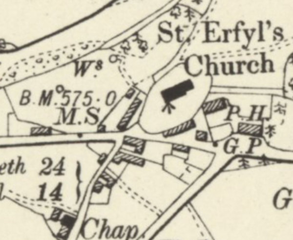
There has, unfortunately, arisen some confusion over recent years as to which well Ffynnon Erfyl actually is. This seems to have been first caused by an incorrect statement in volume 2 of The Lives of the British Saints, which was written by Sabine Baring-Gould and John Fisher in 1908. According to this work, Ffynnon Erfyl is located "about 400 yards from the church", but, by that time, it had been "drained away". This would place the well on the other side of the River Banwy, considerably far from the church, and, crucially, not within the churchyard, which would go against all previous accounts of its location. Unfortunately, this statement was echoed by Francis Jones in his famous Holy Wells of Wales (1954), and, as a result, a completely random well that is located just south of the remains of Llysun Castle has been labelled and photographed by for the Historic Environment Record as "Ffynnon Erfyl". This is not Ffynnon Erfyl.
Confusingly, a well in the correct location, just below the church, has also been labelled as "Ffynnon Erfyl" by the HER. The confusion is advanced further by the fact that old Ordnance Survey maps mark two unnamed wells in the field below the church, both of which were approached by a small footpath (only one of these now remains). It is not clear which one of these was visited on the 26th of July, 1910, by the Royal Commission, who were vague about its location (it is clear that they did not visit the one near Llysun Castle), and, for some reason, they did not believe that it had been arched over:
|
A spring of clear water on the steep bank of the river Banw, to the north-west of the church from which a footpath leads directly to it. It is not known to have been enclosed by masonry. From it the baptismal water for the church font was formerly taken. |
The field below the church, the site of two anonymous wells, one of which must be Ffynnon Erfyl, was visited in 2011, and the site was described very vaguely:
|
There is now no obvious trace of this holy well on the slope below the churchyard. There are however some covered manholes and also some springs. |
|
Access: The well is located on private land. |
*This is the location of the surviving well that is currently marked on Ordnance Survey maps; it is possible that the well to the east, which does not appear to exist, was Ffynnon Erfyl
Images:
Old OS maps are reproduced with the permission of the National Library of Scotland
Copyright 2025 britishholywells.co.uk