 |
Dedication: Saint Garmon Location: Llanfechain Coordinates: 52.77276N, -3.19835W Grid reference: SJ192201 Status: destroyed |
HOME - WALES - MONTGOMERYSHIRE
|
Dedication: Saint Garmon Location: Llanfechain Coordinates: 52.77276N, -3.19835W Grid reference: SJ192201 Status: destroyed |
It is thought that St Garmon visited Llanfechain at some point during the 5th century as part of the missionary work that he carried out in Britain at the orders of the then Pope. Although his name is not today immortalised in the name of the village ("Llanfechain" means "church near the River Cain"), Llanfechain was originally known as "Llanarmon ym Mechain", and the church bears St Garmon's dedication, as did, until recently, his holy well. Local tradition has it that St Garmon preached to the villagers from a small mound in the churchyard, which can still be seen today and is known as "Twmpath Garmon", meaning "Garmon's mound". It is almost absolutely certain that St Garmon visited Llanfechain at some point during his tour, so to speak, of Wales; he is known to have been active in the surrounding area, as several churches nearby are also dedicated to him, like the one at Castle Caereinion, which coincidentally also boasts a (surviving) holy well of St Garmon.
Until the early 20th century, a yew tree, which was said to have been blessed by St Garmon himself, could be seen growing next to the well; when this tree burned down, its wood was made into a prayer desk for the church. It is not clear whether any specific healing powers were ascribed to the well at any point, but the water of Ffynnon Garmon evidently had some sanctity, as it was for centuries used for baptisms in the church, as is related by S. Baring-Gould and John Fisher in The Lives of the British Saints (1911):
|
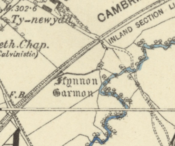
The water for baptisms at Llanfechain continued to be carried, until within last century, from the Ffynnon Armon there, about 200 yards from the church. |
A tithe map of 1839 records that the field in which Ffynnon Armon was located was known as "Maes Ffynnon Annou", which means "field of Ffynnon Armon".
The fate of Ffynnon Armon is truly unfortunate: in the early 2000s, it was planned that the well would be restored, and a footpath built to it from the village. Images still exist of the site as it looked less than two decades ago. The well was, however, destroyed extremely recently to clear the way for two new warehouses, which can be seen from Google Maps.
Images:
Old OS maps are reproduced with the permission of the National Library of Scotland
Copyright 2025 britishholywells.co.uk