 |
Dedication: Saint Mary the Virgin Location: Old Church Stoke Coordinates: 52.552140N, -3.049168W Grid reference: SO289954 Heritage designation: none |
HOME - WALES - MONTGOMERYSHIRE
|
Dedication: Saint Mary the Virgin Location: Old Church Stoke Coordinates: 52.552140N, -3.049168W Grid reference: SO289954 Heritage designation: none |
Very little is known about the early history of Church Stoke's holy well, although its proximity to Roundton Hill, the site of an Iron Age hillfort, makes it possible that it was originally a pagan sacred spring. Despite its rather isolated location, the Lady Well was subject to well-dressing and was a focal point of local celebrations that, until rather recently, took place annually on Holy Thursday. These traditions were described in 1883 in Shropshire Folk-Lore: a Sheaf of Gleanings, which was edited by Charlotte Sophia Burne:
|
Almost exactly the same customs [of drinking ale at the wakes] prevailed at the Lady Well at Old Churchstoke, a township in the adjoining parish of Churchstoke in Montgomeryshire: where the wake obtained the queer name of 'Codger's Wakes,' from the surname (or nickname?) of one Codger of Old Churchstoke who used to 'brew the drink.' Here also the well was 'dressed' with flowers and rushes on Holy Thursday, and the people dropped pins into it, and sat round eating cakes and drinking sugar-and-water from cups passed round the circle. |
The site was also described by Francis Jones in Holy Wells of Wales as being located "in a field below the road leading from Pant to Colton Farm in Church Stoke parish".
Quite strangely, the Lady Well was not visited by the Royal Commission in the early 20th century (or at least I have not been able to find a record of their visit), and the Coflein database states that the well is "now drained". The Lady Well, though never named, has always been marked on Ordnance Survey maps as a "well", and still is today, so Coflein is, in this case, incorrect.
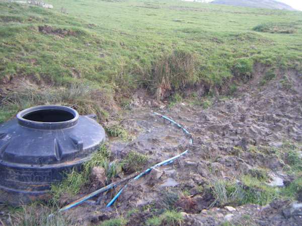
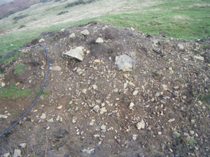
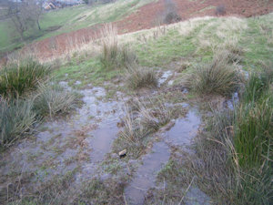
When I visited the well in late November 2024, it was little more than a spring. A large pile of dirt and rubble was heaped next to the well, and the area surrounding the spring looked as though it had been recently dug out; if there ever was a structure surrounding the spring, then this was likely the remains of it. As can be seen in the image above, a large plastic cistern had been buried into the mud next to the spring and seemed to be collecting the water, although when I looked inside it appeared to be quite green. From the site's appearance, the work was very recent, and was not complete: there were to be seen a number of seemingly spontaneously placed wires surrounding the spring. Despite the disruption, the spring was producing a large quantity of clear water that issued down the hill.
 |
 |
|
Access: A public footpath runs past the well. |
Copyright 2025 britishholywells.co.uk