 |
Dedication: Saint Edward the Confessor Location: Knighton Coordinates: 52.33982N, -3.06171W Grid reference: SO277718 Heritage designation: none |
HOME - WALES - RADNORSHIRE
|
Dedication: Saint Edward the Confessor Location: Knighton Coordinates: 52.33982N, -3.06171W Grid reference: SO277718 Heritage designation: none |
St Edward the Confessor, who is the only English king to have been officially canonised by the Pope, had no specific connection to Wales, and was not particularly kind towards the Welsh during his reign in the 11th century. Knighton, however, has not always been classed as a Welsh town; there was much confusion over which side of the border it was located on, until 1535, when King Henry VIII's Acts of Union, which incorporated Wales into the Kingdom of England and created the jurisdiction of England and Wales, confirmed that Knighton is located in Wales. St Edward was the patron saint of England until St George took his place in the 14th century, and it is possible that the dedication of both the well and Knighton's church are a result of the close proximity of Knighton to the English border. The well almost certainly took its dedication from that of the church, which was originally dedicated to St Edward (though during the 18th century it became dedicated to St Laurence), and which has been re-dedicated to St Edward again today.
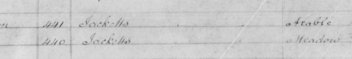
Despite the well's dedication to St Edward, it became known, at some point in its history, as "Jackets Well". This is the name that the well is given on old Ordnance Survey maps (the ones today mark but do not name the spring). It is thought that the name is a corruption of the Welsh word "iachau", which means "to heal". The names of the two fields next to the one in which the well is located are recorded as "Jacketts" on a tithe map apportionment of 1840.
Specifically, the water was believed to be effective in the curing of rheumatism and sprained muscles; according to Francis Jones in The Holy Wells of Wales (1954), the water would be applied "externally". The well was so popular, in fact, that the land owner filled in the spring in the early 19th century. This event was mentioned in a letter that was written "to the Editors of the Archaeologia Cambrensis" in February, 1848, entitled "Preservation of Welsh Antiquities":
|
Gentlemen, -- I have read with much interest, Mr. Jones's paper on the study of Welsh antiquities in your last number, and I entirely agree in the principles therein laid down. Perhaps it may be advisable for the present, principally to concern ourselves in the preservation of all existing visible remains, and let the friendly earth shelter what lies beneath it until better times arise. The demon of destruction is as busy as ever, and the following instances amongst many others, have of late come under my own observation. Upon reading the Pilleth paper in No. 7, I made a point of passing by that secluded spot in a late border-journey. The hall, now the kitchen, in the ancient mansion there, I found had been recently despoiled of its Dais and pillars, and transformed so as to suit the tastes of the beautifiers. In an adjoining parish, the holy well, St. Edward's, to whom the church was dedicated, and which was one of the ancient boundaries of the borough, had been filled up within the last few years, in order to prevent the inhabitants of the place from trampling the grass in the field -- the pure baptismal element will be no more drawn from thence, and the very site will soon be forgotten. In both cases the owners are stated to be persons of wealth and influence, and it is really lamentable to find such insensibility existing in the middle of the nineteenth century. |
Despite this, it does not seem that the well was filled in for long, or at least it retained its fame, as it was referenced by Jonathan Williams in The History of Radnorshire, which was published only a few years later in 1859:
|
The extent of the said borough [Knighton] is from an elder tree or bush growing on the back side of Francis Mason's house, who is now deceased; thence to an ash, late of one Meredith Edwards, barber, deceased; and thence to the further side of the Black Meadow, beyond the river Tame, and so over Tame to Cappero Meadow, late in the possession of Jeremiah Bayliss; thence to a stone bridge in the highway leading from the town of Knighton to Presteigne; thence to an oak in a parcel of land of Mr. Barbley; thence to the top of the Frieth Wood; thence to a crab tree near St. Edward's Well; so over a common, called the Garth... |
Of course, the well had certainly been "un-filled" by 1878 (or the spring, being so strong, just sprung up again very close to its original location), as, by that time, water from Jackets Well was being conveyed to the town as drinking water. This was recorded in Dr Airy's Report to the Local Government Board on the Sanitary State of the Knighton Registration District, which bears the date of the 15th of May, 1878:
|
This main received also in the bottom of the dingle an additional supply from a spring called Jackets Well, which rises by the side of the Wilcome Brook at a point some way higher up the dingle, about the level of the middle part of the town. A valve on this branch prevents regurgitation under pressure of the head of water in the Frydd Reservoir. |
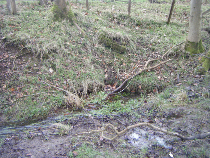
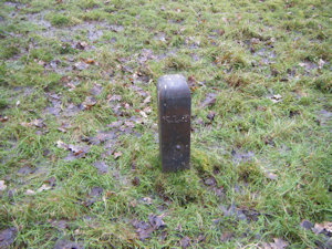
There has been some debate as to whether Jacket's Well and St Edward's Well were, historically, different sites, but they are certainly one and the same: both references above make it clear that St Edward's Well was close to a boundary marker, and that boundary marker can still be seen today, less than ten metres from the "Jackets Well".
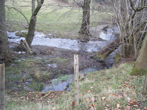
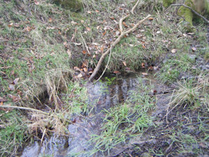
I visited the site in January, 2025, and found the well in very good condition. It was producing a copious amount of clean water, which subsequently issued into a fast-flowing stream. There was no evidence of a structure around the spring, although, according to Archwilio, the site is "now covered over with a brick and concrete structure"; there is nothing to suggest that this has ever been the case, and it certainly is not the case today. The well was partly fed by the run-off from a nearby boggy spot, but the spring was independently producing a large quantity of water.
 |
 |
 |
 |
|
Access: The well is located on private land; permission is to be obtained from the nearby Brookhouse Farm. |
Copyright 2025 britishholywells.co.uk