 |
Dedication: Saint Andrew Location: Coldingham Leisure Park Coordinates: 55.88702N, -2.16671W Grid reference: NT896659 Heritage designation: none |
HOME - SCOTLAND - SCOTTISH BORDERS
|
Dedication: Saint Andrew Location: Coldingham Leisure Park Coordinates: 55.88702N, -2.16671W Grid reference: NT896659 Heritage designation: none |
Coldingham Priory, which became one of the most powerful institutions in the area, was founded by King Edgar in 1098, in place of St Abb's 7th century double monastery, which had been utterly destroyed by the Vikings some centuries previously. The priory followed the Order of St Benedict, and was a subordinate of Durham Cathedral. Although St Andrew's Well undoubtedly owes its existence to this establishment, it evidently did not derive its dedication directly from that of the priory, which, quite unusually, bore a triple patronage of St Abb, St Cuthbert, and St Mary the Virgin.
Despite the fact that he was a biblical figure with no authentic links to Scotland, Andrew has always been a popular Scottish saint, seemingly because his relics are said to have been brought to Fife in the early 8th century. It is likely because of his popularity here that the monks of Coldingham chose St Andrew for the patron of their holy well, perhaps hoping that he would safeguard their water supply. In fact, it is rumoured that St Andrew's Well was the priory's main source of water, and there are a number of 19th century reports of leaden pipes, leading from the spring to the monastery, being uncovered in the ground beneath the two sites, and in Alexander Allan Carr's History of Coldingham Priory (1836), it was asserted that "portions" of these pipes were still "occasionally exposed". According to William King Hunter, writing in 1858 in a very similar volume entitled The History of the Priory of Coldingham, these pipes were "thick and well made". The well's existence is not surprising, as many monastic foundations appear to have dedicated their most important water supply to a saint.
It is not clear whether any local traditions or customs were connected to the spring, but it seems quite unlikely that they would have been, given the fact that the majority, if not all, of its water would have been carried away to the priory. Additionally, St Andrew's Well is located quite a distance from the settlement of Coldingham, on land certainly owned by the monastery, so it may not have been readily accessible to locals during medieval times.
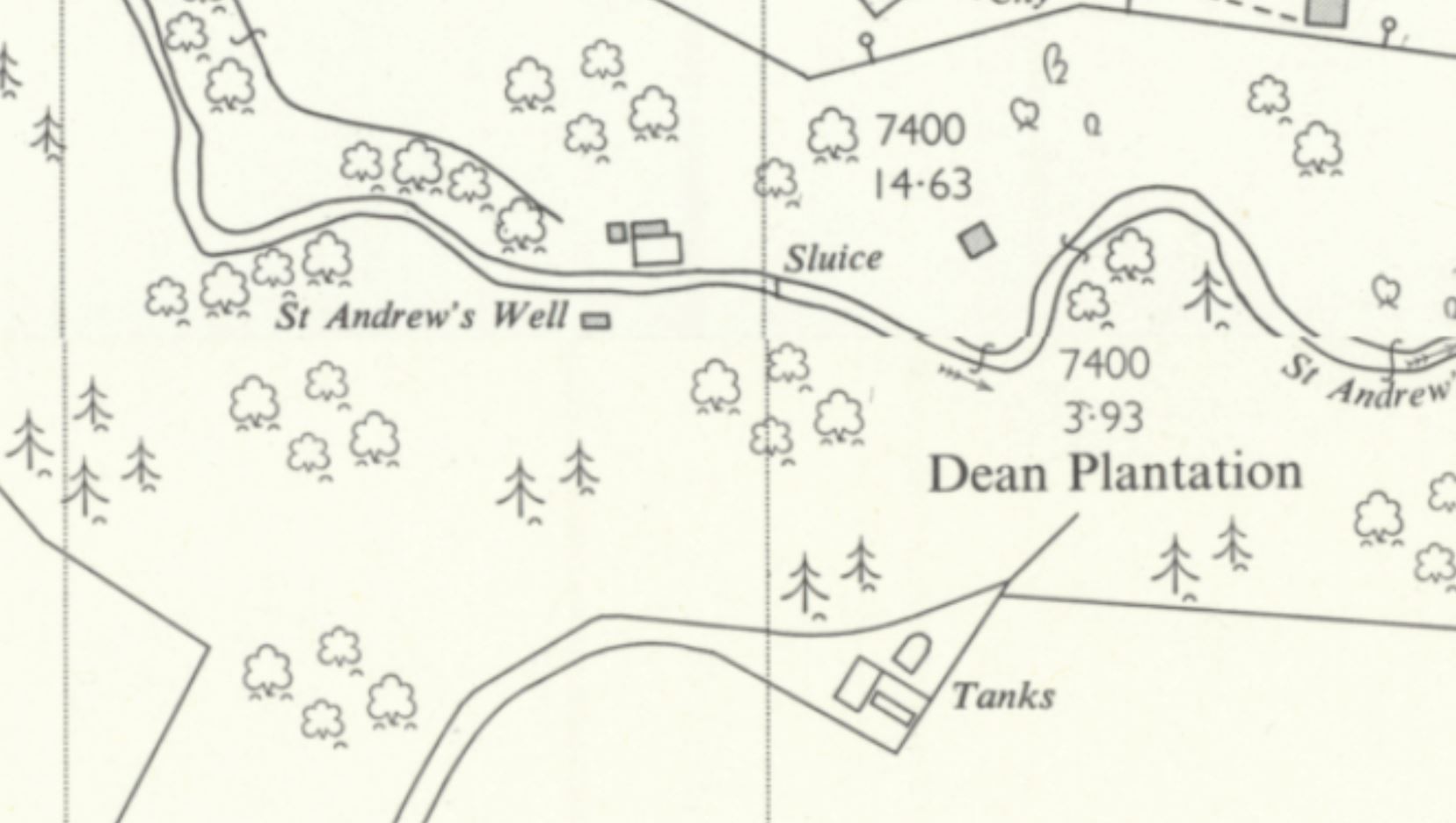
In fact, the only references that I have found to the existence of St Andrew's Well, none of which predate the 19th century, mention the site in the context of being a chief water supply, and it appears that the spring fulfilled this role until the mid 20th century. It must have supplied at least some of Coldingham's inhabitants during the late 19th century, if John Ferguson, who reported that the well "is still in use" in Notices of Remains of Pre-Reformation Churches, &c., in Berwickshire (1892), is to be believed. The site evidently became, if it was not already, the area's foremost water supply, as proven by the 25-inch Ordnance Survey map of 1899, which labelled St Andrew's Well as "Coldingham Water Supply"; earlier maps had simply shown the location of "St. Andrew's Well". This continued until 1908, when maps began to mark a small rectangular building located directly over the spring; at this time, the epitaph "Coldingham Water Supply" was changed to "Berwick County Council". Unsurprisingly, the local sanitary inspector's report for 1934 noted that all of the water used by Coldingham was "passed through meters" (with the rate then being "10d. per 1,000 gallons"), with "nine-tenths" of the resulting sum being "paid direct to the owner of the ground on which St. Andrew's Well is situated".
There is, unfortunately, no record of how exactly St Andrew's Well would have looked in medieval times. Nevertheless, it is clear that the site has been altered and remodelled a number of times in the last two centuries alone. The first clue as to when the well may have been altered lies in the fact that one of the stones that make up the parapet of a Category C listed bridge, which, located in the centre of Coldingham, spans St Andrew's Burn, is mysteriously inscribed with the following text:
|
From St Andrew's Well 1870 |
Although the Historic Environment Record expresses uncertainty as to the specific date of this bridge's construction, it is obvious that this stone must have been placed here in 1870. Intriguingly, this stone is completely identical (excepting the inscription) to the other stone slabs that the parapet consists of; if the inscribed stone really was taken from St Andrew's Well in the late 19th century, then the rest of the parapet must have been too. This suggests that whatever structure St Andrew's Well was surrounded by, prior to 1870, was taken down in that year and turned into, or at least added to, a local bridge. Something new was, undoubtedly, then constructed in place of the original building, and it seems logical that this new construction would have had something to do with the fact that the 1899 OS map pinpoints the spring as "Coldingham Water Supply". No maps were published between the years of 1857 and 1899, meaning that St Andrew's Well could have become the main water supply (assuming that it was not already), or at least been changed to serve that purpose more efficiently, at any point during this time.
This does not, however, seem to have been the last alteration that the holy well was subject to. As previously noted, both the 25-inch and 6-inch OS maps of 1908 marked a rectangular building at the site, which had not before been noted on any maps, including on the 6-inch map of 1900; evidently this building was erected at some point between the years of 1900 and 1908. Even this does not appear to have been sufficient for the growing population, as it was noted in the sanitary inspector's report of 1932 that there was "no storage in connection with the Coldingham supply", meaning that, when the spring produced less water in the summer, there was "an undoubted shortage". Although this issue seems to have been corrected by 1934, the inspector's report for that year recorded that a "scheme of improvements" had been drawn up, which, it was planned, would be "completed early in the ensuing year". This scheme included "the erection of a new storage tank" ("new" suggesting that one, by then, already existed), and the "laying of a new pipe from the tank down to the village". This "new storage tank", which must have been constructed in early 1935, is almost certainly the one that survives at the site of St Andrew's Well today.
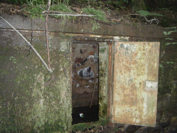
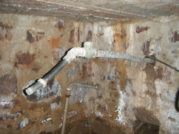
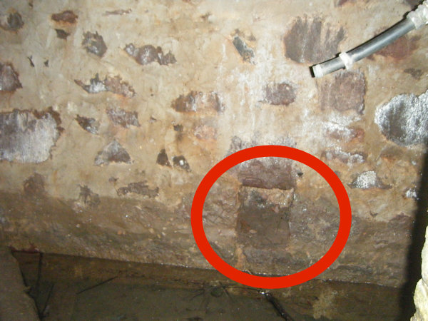
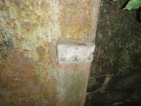
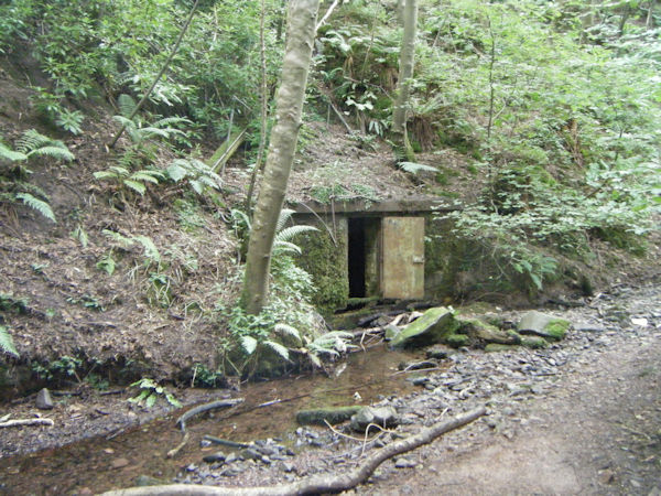
When I visited St Andrew's Well in July 2025, the spring was evidently still flowing strongly, although it seems very unlikely that it is still used as a water supply today. The well was housed in a relatively large rectangular building, the northern wall of which was constructed of bricks faced with stones. The other three walls, all built into the hillside and not visible from the outside, seemed to be older and built of large stones; three recesses in these walls may once have supported a wooden floor. The structure was covered with a flat slab of concrete, and sealed by a large rusted door (which was evidently once locked). The western half of this building contained a variety of equipment and metal pipes, one of which looked similar to a pump. Overall, it was in a decent condition, and bore the hallmarks of an early 20th century construction.
 |
 |
 |
 |
 |
|
Access: The well is located at the side of a stream on the edge of a holiday park; there is a path through the park that leads past the well. |
Images:
Old OS maps are reproduced with the permission of the National Library of Scotland
Copyright 2025 britishholywells.co.uk